| Year
| Western 80 Acres of 1848 Plot
Western Half of Northwest Quadrant of Section 33 |
Eastern 80 Acres of 1848 Plot
Eastern Half of Northwest Quadrant of Section 33 |
Western 80 Acres of 1866 Plot
Western Half of Southeast Quadrant of Section 28 |
Eastern 80 Acres of 1866 Plot
Eastern Half of Southeast Quadrant of Section 28 |
|---|
| 1827 |
U.S. Congress gives Illinois & Michigan Canal odd-numbered sections of land five miles on either side of proposed Canal |
U.S. Congress gives Illinois & Michigan Canal odd-numbered sections of land five miles on either side of proposed Canal |
Owned by Federal Government |
Owned by Federal Government |
| 1835 |
Owned by Illinois & Michigan Canal |
Owned by Illinois & Michigan Canal |
Samuel Anderson purchases from Federal Government on June 22; source: Initial Land Sales |
Samuel Anderson purchases from Federal Government on June 22; source: Initial Land Sales |
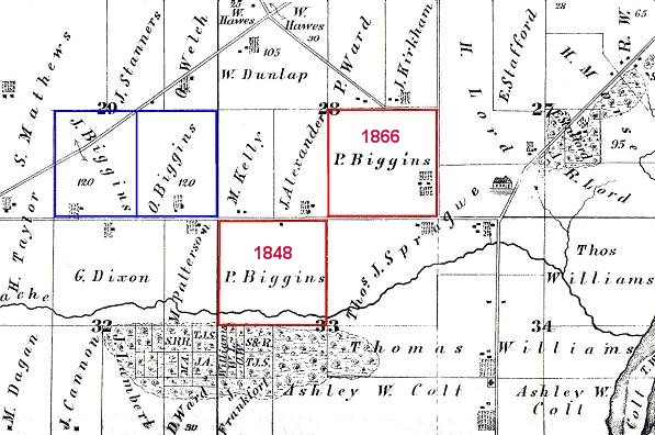
| 1848 |
Patrick Biggins purchases from Illinois & Michigan Canal on September 11; source: Initial Land Sales |
Patrick Biggins purchases from Illinois & Michigan Canal on September 11; source: Initial Land Sales |
|
|
| 1862 |
|
|
Owned by A. Amsden based on Rural Historic Structure Survey by Will County Land Use Department in 2001, PIN 02-28-400-003 |
Owned by A. Amsden based on Rural Historic Structure Survey by Will County Land Use Department in 2001 (original farmstead at east end of quarter-section), PIN 02-28-400-003 |
| 1866 |
|
|
Patrick Biggins purchases from Charles E. Boyer on June 23 for $6,500 |
Patrick Biggins purchases from Charles E. Boyer on June 23, included in sale of western half |
| 1872 |
Directory: resident Patrick Bagan, farmer |
Directory: resident Patrick Bagan, farmer |
Directory: resident Patrick Bagan sr, farmer |
Directory: resident Patrick Bagan sr, farmer |
| 1873 |
Plat map: owned by P. Biggins |
Plat map: owned by P. Biggins |
Plat map: owned by P. Biggins |
Plat map: owned by P. Biggins (original farmstead at east end of quarter-section) |
| 1873-1874 |
Philip Biggins purchases from Patrick Biggins for $2,600 on March 18, 1874 |
Francis Biggins purchases from Patrick Biggins for $4,000 on January 11, 1873 |
James A. Biggins purchases from Patrick Biggins for $3,100 on March 18, 1874 |
Catherine Biggins purchases from Patrick Biggins for $4,000 on March 18, 1874 |
| 1875 |
Philip Biggins marries Sarah McNally in Bridgeport area of Chicago on August 26 |
|
James A. Biggins marries Elizabeth Healy in Chicago on April 22 |
|
| 1876 |
|
Catherine Biggins purchases from Francis Biggins for $4,000 on December 18 |
|
|
| 1880 |
Census: Philip Biggins, farmer, living with his own family in DuPage Township |
Census: Francis Biggins living with Benjamin Barrett family in DuPage Township |
Census: James A. Biggins, farmer, living with his own family in DuPage Township |
Census: Catherine Biggins living with her father Patrick in DuPage Township |
| 1885 |
Philip Biggins family moves to Naperville |
Francis Biggins moves to Joliet |
|
Catherine Biggins moves to Joliet |
| 1889 |
Will County Circuit Court orders Sheriff to sell Philip Biggins' 80 acres to Fithian & Cowing to settle debt to estate of Barrett B. Clark |
Will County Circuit Court orders Sheriff to sell Francis Biggins' 40 acres to Fithian & Cowing to settle debt to estate George J. Munroe |
|
|
| 1890 |
|
|
James A. Biggins dies on March 16, and his wife Elizabeth Healy Biggins continues farming |
|
| 1891 |
|
Will County Coroner�s Record of September 24 reports that Francis Biggins was run over by a Chicago & Alton railroad train in Lockport while trying to board it under influence of liquor |
|
|
| 1893 |
Plat map: owned by Michael Kelly |
Plat map: owned by Harris & Donnell et al. |
Plat map: owned by Jas. A. Biggins |
Plat map: owned by Margaret Reardon |
| 1904 |
|
|
Elizabeth Biggins moves to Joliet |
|
| 1909 |
Plat map: owned by Michael Kelly Estate |
Plat map: owned by E. Biggins |
Plat map: owned by E. Biggins |
Plat map: owned by J. J. Lehy |
| 1920 or 1925 |
Plat map: owned by Edward Blum |
Plat map: owned by E. Biggins |
Plat map: owned by E. Biggins |
Plat map: owned by J. J. Lehy |
| 1930 or 1933 |
Plat map: owned by Albert Hassert |
Plat map: owned by H. R. Phelps |
Plat map: owned by H. R. Phelps |
Plat map: owned by J. J. Leahy |
| 1963 |
Plat map: owned by Albert Hassert |
Plat map: owned by George Mathers |
Plat map: owned by George Mathers |
Plat map: residential-Hampton Park 2 West |
| 1966 |
Plat map: owned by Albert Hassert |
Plat map: owned by George Mathers |
Plat map: owned by George Mathers |
Plat map: residential-Hampton Park 2 West |
| 1972 |
Plat map: owned by Roy F. Hassert |
Plat map: owned by George Mathers |
Plat map: owned by George Mathers |
Plat map: residential-Hampton Park 2 West |
| 1982 |
Plat map: owned by Roy F. Hassert |
Plat map: owned by George Mathers |
Plat map: owned by George Mathers |
Plat map: residential-Hampton Park 2 West |
| 1988 |
Plat map: owned by Irene T. Schindel |
Plat map: owned by George Mather |
Plat map: owned by George Mather |
Plat map: residential-Hampton Park 2 West |
| 1991 |
Annexed to Romeoville; Lakewood Estates Partners, developer; Midwest Bank & Trust Company Trust No. 88-09-5599 dated 9-10-88, owner |
|
|
|
| 1992 |
Plat map: owned by Midwest Bank & Trust Co. |
Plat map: owned by George L. Mather |
Plat map: owned by George L. Mather |
Plat map: residential-Hampton Park 2 West |
| 1994 |
Plat map: residential-Lakewood Estates |
Plat map: owned by George L. Mather |
Plat map: owned by George L. Mather |
Plat map: residential-Hampton Park 2 West |
| 2002 |
Plat map: residential-Lakewood Estates |
Plat map: owned by George L. Mather; George L. Mather dies on February 20 |
Plat map: owned by George L. Mather; George L. Mather dies on February 20 |
Plat map: residential-Hampton Park 2 West |
| 2005 |
|
Opening of the Beverly Skoff Elementary School and the John J. Lukancic Middle School |
|
|
| 2007 |
|
|
Opening of Misty Ridge, a new community of 166 homes, built by Beechen & Dill Builders, Inc. |
|
 Patrick and Bridget Biggins - Farm History